News

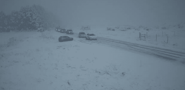
As the cold front continues its path across the lower South Island, the wintry conditions have intensified, causing further disruptions. The NZ Transport Agency reports that the snow showers have intensified in the Southland region, particularly in the area of SH94 Gorge Hill, situated between Mossburn and Te Anau.
The New Zealand Metservice forecast indicates that snow is expected above 400 or 500 meters, with heavier falls anticipated above 700 meters. In these higher areas, snow accumulations may approach the warning criteria of more than 10 cm in just six hours.
The most significantly affected regions by the snowfall are predicted to be the northern hills of Southland, extending north to the Waitaki River. However, the lower-lying parts of North Otago, Dunedin, and Clutha are likely to be spared from the brunt of the wintry conditions.
In light of these conditions, drivers are strongly advised to exercise caution on the roads. It is crucial to stay informed about the latest weather updates and road conditions before embarking on any travel.
Taking necessary precautions and heeding the warnings will help ensure the safety of both drivers and pedestrians.
Fortunately, there is some respite in sight. The cold front is expected to progress eastwards by tomorrow, offering a gradual improvement in the weather conditions.
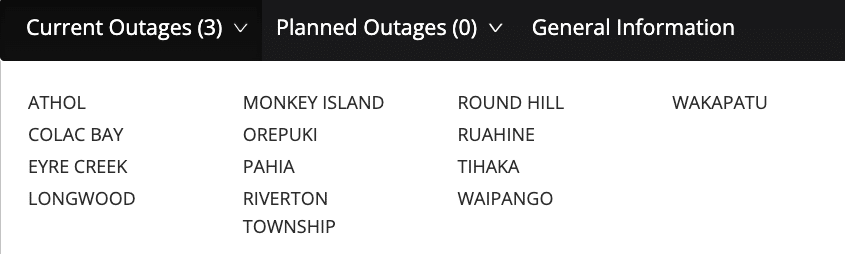
The Powernet website was showing a number of towns in Southland with power outages.