Weather

A wintry storm has gripped Southland, bringing severe winds to much of the region, including Invercargill and Stewart Island.
Strong Winds Cause Damage Across Southland
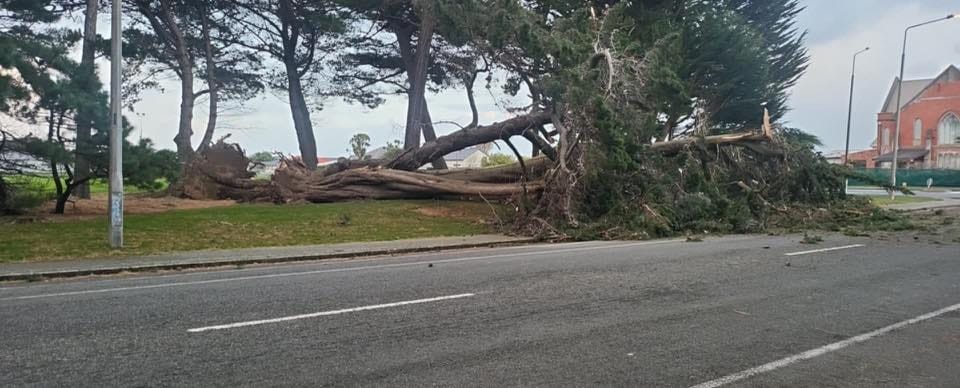
• Severe winds brought down trees and cut power in parts of Invercargill overnight
• Residents are advised to secure outdoor items and drive cautiously due to ongoing gusts
• Conditions expected to ease this evening, with calmer weather returning on Sunday Severe winds have battered Invercargill and wider Southland, causing power cuts,
MetService and WeatherWatch have both issued urgent alerts as a cold front continues moving north across the lower South Island. The key concerns are snowfall on Milford Road and gale-force winds set to affect several southern districts through to Saturday afternoon.
Snowfall On Milford Road
From 10:00 AM today until midnight, a Road Snowfall Warning remains active for Milford Road (SH94). Snow is already falling, with between 10 and 15 centimetres expected to settle above 800 metres, and light snow possible down to 600 metres. Conditions are likely to be worst near Homer Tunnel. Waka Kotahi has warned that the road may close if weather conditions deteriorate further, with an update expected by 9:00 PM tonight. Travellers are urged to take extra care, carry snow chains, dress warmly, and have emergency supplies on hand.
Severe Winds Across Southland
A Strong Wind Warning is now in force for Southern Fiordland, Southland, Stewart Island, Clutha, and Dunedin. Winds are expected to peak between Friday afternoon and Saturday morning, with gusts potentially reaching 130 km/h, especially near the coast.
While current warnings remain at Orange level, authorities say there is a small chance conditions could worsen and trigger a Red Warning. The wild weather may cause damage to trees and powerlines, and make travel risky, particularly for high-sided vehicles and motorcycles.
Forecast For Invercargill And Surrounding Areas
Invercargill residents should expect cold, windy weather with temperatures between 4–8°C. Rain and showers, possibly heavy at times, may turn to sleet or snow in elevated suburbs. Snow is not expected to settle at lower levels, but wind chill could make conditions feel significantly colder.
Coastal areas, including Stewart Island, are forecast to face the strongest gales and most intense squally showers, with a chance of hail and even isolated thunderstorms.
Authorities are urging people to stay informed, plan travel carefully, and prepare for rapidly changing weather through Friday night and into Saturday.