Weather
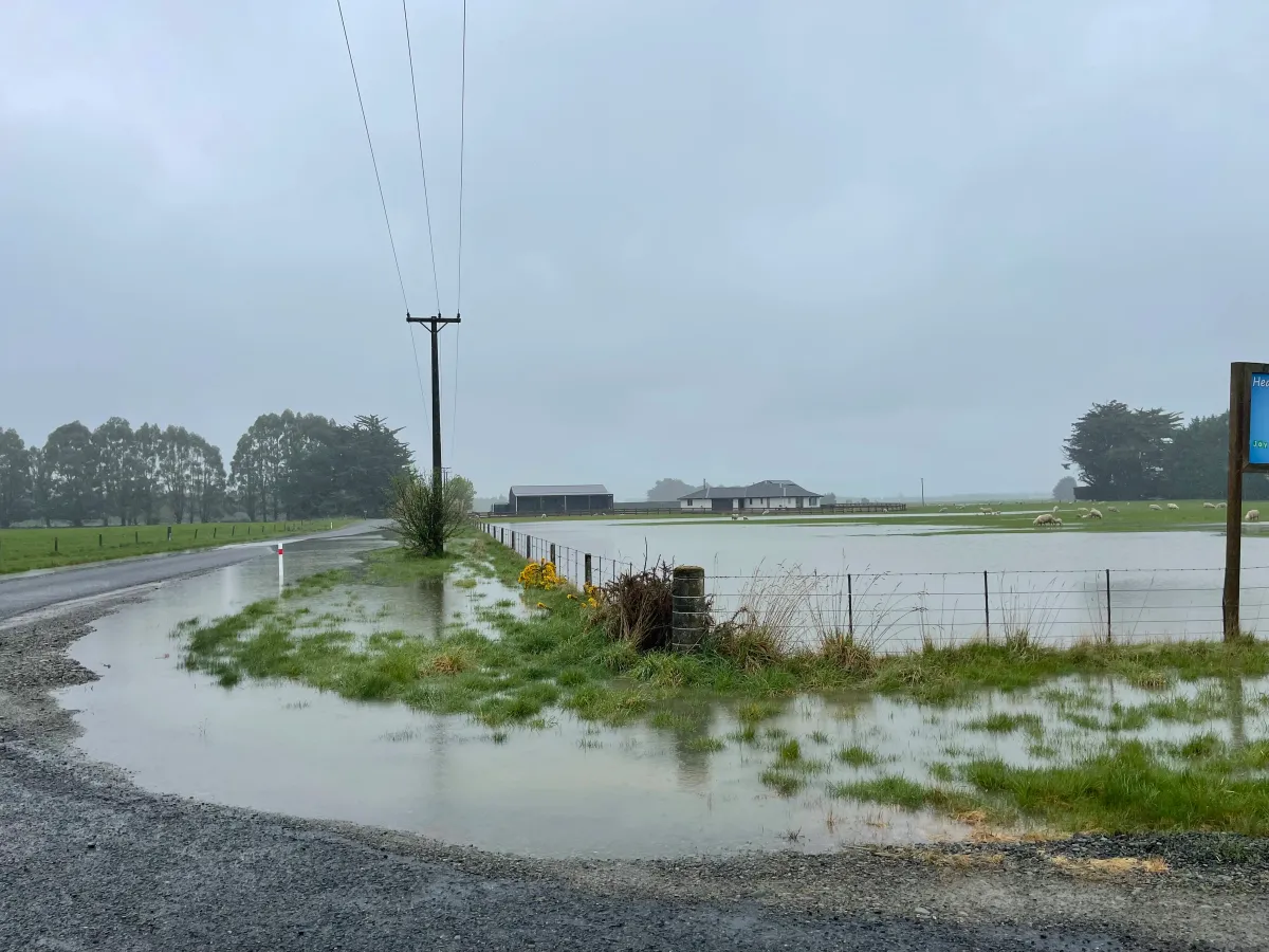

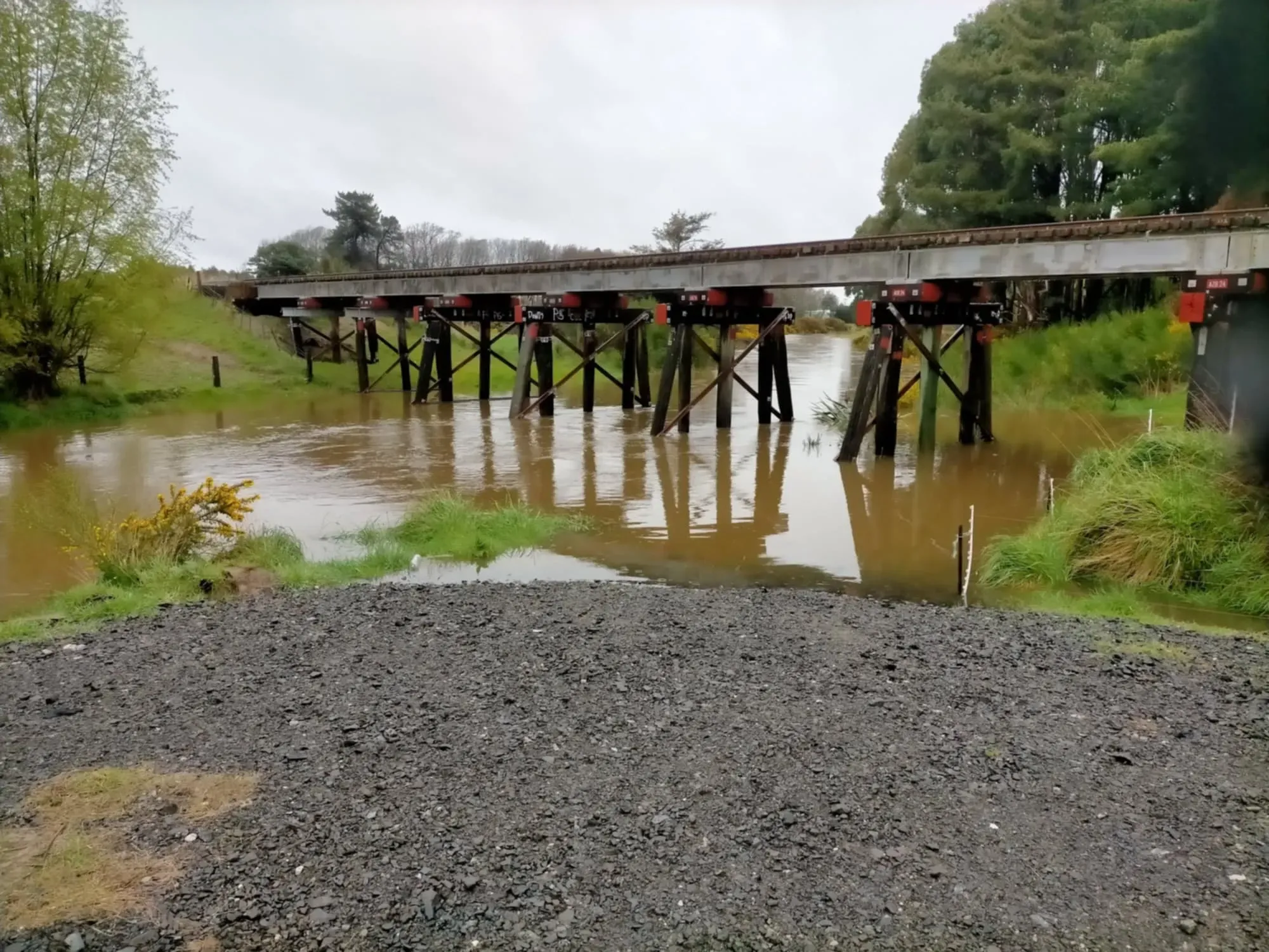
- Several Southland roads closed or affected due to flooding and hazardous conditions.
- Motorists urged to exercise caution, with signage in place on affected routes.
- Updated information on closures and flooding available through local council websites.
Update: 12 noon Saturday 5 October: NZTA Road Update: #3
CLOSED - Ferry Road and West Plains Road
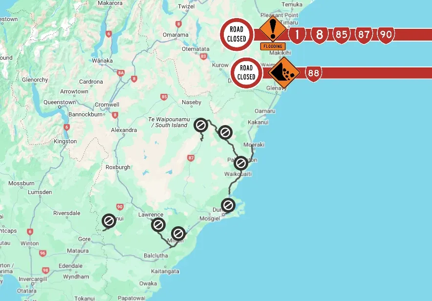
SH1 south and north of Dunedin - south open, north this afternoon at latest
SH1 south of Dunedin, a small section south of Milton: Now reopened.
SH1 north of Dunedin: NZTA hopes to have SH1 between Evansdale and Hampden opened by 1 pm at the latest. There is 300 cubic metres of rock to move from a slip south of Waikouaiti with many smaller slips on the road shoulders so crews are hard at it.
- Check the web map/ traffic updates for this section of highway this morning: https://www.journeys.nzta.govt.nz/highway-conditions/otago
Update: 9:50am Saturday 5 October: Southland District Council Area Road Update:
Full list https://www.facebook.com/share/p/bGiyXVYss65AFhfo/
Update: 9:30am Saturday 5 October: NZTA Road Update #2
State Highway 1 has now RE-OPENED through Milton township. Additionally, both SH8 between Lawrence and Milton and SH85 between Kyeburn and Palmerston have RE-OPENED.
The following roads remain CLOSED as of 9:30am, Saturday 5 October.
• SH1 Hampden to Evansdale - Flooding
• SH87 Kyeburn to Hyde - Road damage
• SH88 Forsyth Barr Stadium to Port Chalmers - Slip
• SH90 Waikoikoi to Tapanui - Flooding
Update: 7:30am Saturday 5 October: NZTA Road Update
These roads remain CLOSED as of 6am, Sat 5 Oct
• SH1 Hampden to Evansdale
• SH1 Milton, Allison Rd to Mill St
• SH8 Lawrence to Milton
• SH85 Kyeburn to Palmerston
• SH87 Kyeburn to Hyde
• SH88 FB Stadium to Port Chalmers
• SH90 Waikoikoi to Tapanui
Update: 6:50am Saturday 5 October: Clutha District Council
Public Advisory: Wastewater Treatment Plant Overflows
We would like to inform the public that the following wastewater treatment plants are currently experiencing overflows:
Tapanui, Balclutha, Milton, Kaitangata, Waihola, Owaka, Kaka Point.
There have been reports of human waste present around some of these areas. As a precaution, please assume that all floodwaters are contaminated with sewage and chemicals. We strongly advise against any contact with floodwater to avoid potential health risks.
For your safety, avoid affected areas whenever possible and take necessary precautions. Stay informed and follow official updates from local authorities.
If you experience any symptoms such as nausea, vomiting, or diarrhea, seek medical attention immediately.
latest list of roads closed due to flooding.
https://www.cluthadc.govt.nz/council/alerts?item=id%3A2rpe3gqou17q9s73g0xi
Update: 9pm Waihola to Milton has reopened but…Due to flooding, State Highway 1 is closed between Allison Road and Mill Street intersection. Road users are advised to avoid the area or delay their journey.
These conditions are changeable given the water flowing downstream and affecting different areas of highway overnight. People should not drive through deep water, particularly in the dark, stay home tonight.
Update 5pm Friday 4th Oct. NZTA and video message from Southland District Mayor Rob Scott.
State Highway Updates:
- SH1 - South of Dunedin (between Waihola and Milton)
Closure in effect. Freight traffic may need to use the Lindis Pass (Tarras to Omarama) to reach Canterbury or Central Otago/Southland.
More details here. - SH87 - Kyeburn to Hyde (north of Middlemarch)
Closed due to flooding. Please delay your travel.
More details here. - SH90 - Waikoikoi to Tapanui
Closed due to flooding. Detour in place.
More details here.
Several Southland roads have been closed due to flooding and hazardous conditions, with updates provided by local authorities.
Related:
MetService Issues Rain Watch For Southland & Clutha
$50,000 in Support for Southland & Otago Farmers Welcomed
$50,000 in Support for Southland & Otago Farmers Welcomed
Invercargill MP Penny Simmonds expressed her approval of an additional $50,000 in Government support announced today for farmers in Southland and parts of Otago. Related: Road Closures And Flooding Updates In Southland “This funding will assist farmers and rural communities in our region, through organisations such as the Southland
Update– 4 October 2024, 2.30pm: Dunedin Weather Event
Following the declaration of a State of Emergency at 11.55pm on Thursday, 3 October, emergency staff, agencies, and volunteers have been working around the clock.
All major routes into Dunedin are now closed and expected to remain so overnight:
- SH1 northbound closed at Waikouaiti
- SH1 southbound closed at Waihola
- SH88 closed to Port Chalmers
- SH85 closed at Palmerston
- SH87 closed at Kyeburn Bridge
Civil Defence Controller Chris Henderson: “Road conditions are unpredictable. We urge people to avoid driving unless it’s essential. Check on your neighbours, stay safe, and keep informed through official channels.
Update 12:25pm: NZTA Road Closure: SH 1 Waihola to Milton
Due to flooding, State Highway 1 is closed between Waihola and Milton. Avoid the area or delay your journey if possible.
Updated 11am: All state highways in Southland are open. We have some patches of surface flooding as listed below. Please slow down and drive to the conditions:-
SH6 Lumsden-Dipton highway at the Bell Road intersection
SH6 Kingston-Garston hgihway near Kingston
SH94 Waimea highway north of Mandeville
SH96 Winton-Wreys Bush highway at Hundred Line Road intersection
SH99 Orepuki-Riverton highway at Stick Road
SH99 Tuatapere-Orepuki highway at Block Road
Road Closures:
- South Hillend Dipton Road: Closed at Taurangatura Camp.
- Orawia Pukemaori Road: Closed (signage being installed).
- Otautau Bridge (Main Street): Closed.
- Lindsay Calcium Road: Closed.
- West Plains Taramoa Road: Closed at Taramoa intersection.
- Pyramid Bridge: Closed on Southland district side (Riversdale-Pyramid Bridge Road).
- Piano Flat Road: Closed at Waikaia township turnoff.
Flooded Roads:
- Otautau Nightcaps Road: Flooded between Waikouro Wairio and Otautau Wreys Bush Road.
- Oreti Drummond Road: Flooded but passable at Drummond end.
- Riverton Otautau Road: Flooded at multiple points.
Updates From 8:15 AM, Friday, 4/10:
- Calder Road and Forbes Road Intersection (Lochiel): Flooded (signs installed).
- Flooding signs are also up on Fleming, Holz, and Mataura Island Titiroa Roads; however, these roads are not closed yet.
Notices From Thursday, 3/10:
Motorists are advised to drive cautiously on the following roads due to potential hazards:
- Dipton-Castlerock Road (Castlerock end).
- Riversdale Waikaia Road.
- Felton Road (White Hill).
- Gallagher Road (Mossburn).
- Centre Hill Road (Mossburn).
- Edwards Road (Mossburn).
- Sutherland Road (Mossburn).
- Riverton Otautau Road (Otautau).
For ongoing updates and more detailed information, refer to the Southland District Council, Environment Southland, and the New Zealand Transport Agency.
Clutha’s Emergency Operations Centre was stood up overnight and we’re monitoring the Clutha River.
We have had requests for sandbags which have been delivered to the Milton Community Library for people to collect. Sandbags at King Engineering, Balclutha however, you will need to bring your own shovel.
Roads
Below is a list of the roads affected. However, due to the nature of this event and how widespread it is we are unable to sign out every patch of surface flooding. Our contractors are focusing on the the most dangerous areas.
Where possible we advise that people should stay home and not drive around taking photos.
If you see a Road Closed sign please don’t drive past it as we don’t want people risking their own safety.
Flooding:
- Mt Wallace Rd ROAD CLOSED
- Summerhill Rd ROAD CLOSED
- Kelso block at West Otago ROADS CLOSED
- Finch Rd ROAD CLOSED
- Circle Hill Rd ROAD CLOSED
- Butts Rd ROAD CLOSED
- North Branch Rd ROAD CLOSED
- Alexander Rd ROAD CLOSED
- Table Hill Rd ROAD CLOSED
- Titri Rd ROAD CLOSED
- Elliotvale Rd ROAD CLOSED
- Toko Mouth Rd ROAD CLOSED
- Back Rd, Milton
- Kakapuaka Rd ROAD CLOSED
- Waitepeka Rd/Guernsey Hill Rd ROAD CLOSED
- Karoro Creek Rd ROAD CLOSED
- Glenomaru Rd ROAD CLOSED (no signs)
- Kaka Point Rd at Brookdale Rd and by 50km sign
- Pillans Rd/Clutha Valley Rd
- Wairuna Settlement Rd
- Brooksdale Rd, West Otago
- Berwick Rd/Young Rd
- Gormack St/Moir St intersection
- Kai Highway at Railway Bridge
- High Street/Stewart Street Balclutha
- Barnego Rd
- Frances Street, Balclutha ROAD CLOSED
- Taieri Ferry Rd ROAD CLOSED
- Coast Rd
- Bruce Road, Milton CLOSED
- Tapanui- Waikoikoi Highway CLOSED
- Ahuriri Flat Road CLOSED
- Koi Flat Road, Pomahaka CLOSED
- Papatowai Highway, Maclennan CLOSED
- Centre Road, Maclennan CLOSED
- Rongahere Road CLOSED
- Puerua Valley Road, Lochindorb CLOSED
- Waikoata Valley Road CLOSED
- Clutha Valley Road, Hillend
- Moir Street, Balclutha
- Milton Highway
Slips:
- Owaka Highway by Romahapa
- Puaho Road
- The Nuggets Rd ROAD CLOSED
- Finlayson Rd
- Akatore Rd
- Moturata Rd
- Summer Hill Road
- Finalyson Road, Waihola
- Moturata Road, Taieri Beach
- Papatowai Highway, Tarara
- Tautuku Beach
Water and Wastewater:
Our water wastewater teams are busy out monitoring and addressing any issues affected by the heavy rainfall.
Many of our wastewater pumpstations have had overflows. We advise people to stay out of floodwaters and treat as there is a chance that the water is contaminated.
Waste Services
We are closely monitoring the ongoing red weather warning for heavy rain in Clutha and its impact on our waste and recycling services.
The safety of our team and the community is our top priority. We are reviewing the situation constantly and may need to make changes to our services to ensure everyone's well-being.
What to do:
- Stay Informed: Please check our website and social media pages regularly for updates on service changes and disruptions.
- Report Issues: If you notice any issues related to refuse or recycling collection in your area, please report them to us through our website or social media channels.
- Prioritise Safety: Please exercise caution and avoid unnecessary travel during this severe weather event, if you can wait until the next collection please do.