Thunderstorms have developed in Southland, Clutha and Central Otago this afternoon. Some of these thunderstorms are expected to bring heavy rain with intensities of 10 to 25mm per hour and hail 10 to 20mm in diameter. Additionally there is a moderate risk that some slow moving thunderstorms could be
Cold southerlies are expected to affect the south of the South Island from this afternoon through to later Tuesday, bringing wintry conditions to the south of the South Island. Snow should lower to 400 to 500m at times, with significant snow accumulation above 800m. A heavy snow warning is now in fo
A strong, cold southwest flow will spread over the country today. The strongest winds are likely to affect eastern parts of the lower South Island during Tuesday and early Wednesday. This Watch is for the likelihood that west to southwest gales could approach severe gale about North Otago, Dunedin,
Periods of heavy rain, northwesterly gales and significant snow for parts of the South Island. An active front, preceded by a strong to gale northwesterly flow, is expected to move onto the South Island Sunday evening and move northeastwards over the Island during Monday. This Watch is for the possi
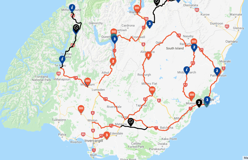
SH 93 Clinton to Mataura road closed due to snow. Detour route: n/a Heavy snow for parts of the lower South Island A cold showery southwesterly flow covering the South Island, is expected to spread over the North Island today (Monday). Snow is expected to 200 metres across the lower South Island, es
Current travel events for this region are listed below. NZTA will be adding more travel routes to as required. Southland UPDATE: SH93 Mataura to Clinton – Snow – ROAD CLOSED – Use SH1. UPDATE: SH94 Te Anau to Milford Sound – Snow– ROAD CLOSED – Milford Road closed overnight from the Lower Hollyford
Snow has starting falling in parts of Southland with reports from Gore that snow/sleet on roads Gore/Clinton causing issues for light vehicles… Metservice and Weatherwatch say Snow is expected to fall to low levels in the South Island tonight and through to Wednesday morning. This Watch is for the p
A front is forecast to approach the lower South Island Tuesday morning, bringing rain to western areas and another period of west to northwest gales to many parts of the south. The strongest winds are expected to affect Fiordland, Southland, Otago, and Canterbury south of the Rakaia River. A Severe